- About
- Program
- Registration
- Experience
- Student & EC
- Hotel/Travel
- Sponsor/Exhibit
- Resources & More
CERF 2023 WorkshopReturn to Workshop Schedule
Sign up for this workshop when you register for CERF 2023. Already registered but want to add this workshop? Email the CERF Office for assistance!
|
||||||||||||
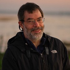
| David Wilcox | |
|
|
David Wilcox helps manage and provides GIS and programming support for the annual Chesapeake Bay SAV aerial monitoring program at the Virginia Institute of Marine Science, College of William & Mary. Dave received his Master’s in Geography from the Ohio State University, and has more than two decades of SAV mapping experience. |
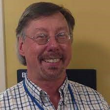
| Mark Finkbiener | |
|
|
Mark Finkbeiner leads OCM’s Ocean Data and Tools project, which focuses on supporting the coastal and marine planning community in a wide range of issue areas. Major activities in this project include the Marine Cadastre, the OceanReports Tool, supporting the Coastal and Marine Ecological Classification Standard (CMECS), and other marine mapping and data development efforts. Mark serves on steering committees for several seagrass Communities of Practice and working groups related to marine habitat. Mark has over 27 year of experience in remote sensing, GIS, and benthic mapping. His background includes work in wetland delineation, wellhead protection, land cover change detection, image analysis, and remote sensing training. |
Announcements
SAVE THE DATE
Join Us in Richmond, Virginia, USA
9–13 November 2025
Our Sponsors
@CERFScience
View this profile on Instagram